Halachó: Church Plaza Vibes, Sihó Ruins & Bécal Hat Caves Nearby
What Makes This Special
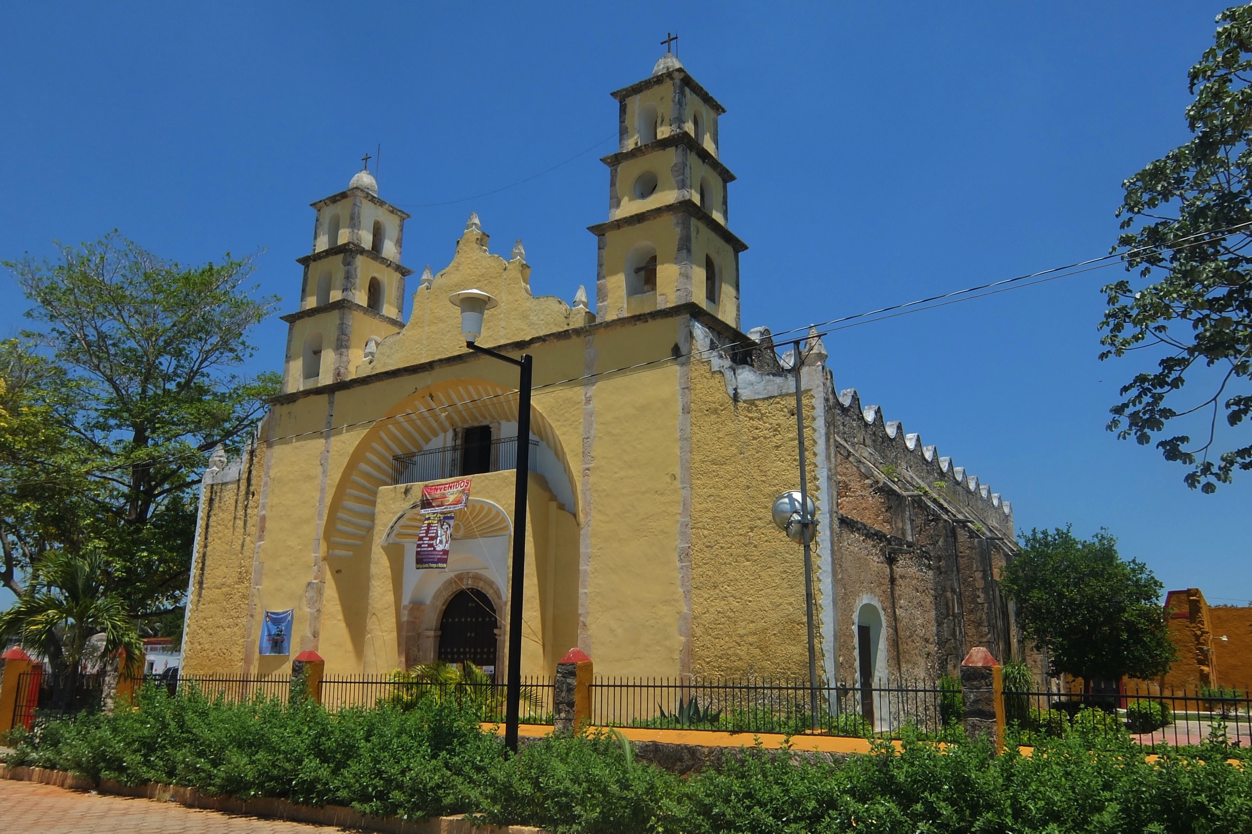
Right on the Mérida–Campeche highway, Halachó is a mellow plaza town anchored by the colonial Parroquia de Santiago Apóstol. It’s also the jumping-off point for the little-known Maya remains at Sihó (within the municipality) and quick cross-border craft visits to Bécal, Campeche, where jipijapa hats are woven in cool limestone caves.
History
Halachó sits on the old Camino Real to Campeche. The parish complex of Santiago Apóstol traces to the colonial era and served the rural curato along this route; today its clean, undulating façade still fronts the main square. The municipality’s name commonly derives from Maya words for “cañizo/carrizo” and “ratón,” while another local telling links it to Halacho’ob, “hombres verdaderamente sabios.”
Practical Information
- Entry/Access: Town and plaza are free to visit; church is generally open around services.
- Parador Halachó (highway rest stop): Open 24/7 with toilets, showers, food stands, craft stalls, and overnight vehicle parking—handy if you’re road-tripping.
- Sihó ruins: Dispersed mounds on ejido/private lands in the Sihó area; there’s no official INAH ticket booth. Ask locally for access and go with a community guide.
- Payments: Cash (MXN) recommended; small shops rarely take cards.
- Recommended Visit Length: 2–4 hours in town; make it a full day by adding Bécal or Oxkintok/Calcehtok.
What to Expect
Church & plaza time: Stroll the square, photograph the Santiago Apóstol façade, and catch evening life around the letters. Simple loncherías and fruit stands cluster nearby.
Sihó (archaeology-in-the-brush): Low platforms, stair bases and scattered groups show an early Puuc-area footprint; terrain is uneven and unmarked—treat it like a countryside hike with ruins.
Craft detour to Bécal (Campeche): 15–16 km west, artisans weave sombreros de jipijapa in humid cave-workshops—an eye-opening, inexpensive cultural stop.
Getting There
From Mérida (≈78–83 km; ~1 h 15–1 h 40): Direct buses run from Mérida (TAME/Noreste corridor) toward Halachó/Calkiní along Hwy 180; typical one-way fares land in the budget range. Driving is straightforward via 180.
- Bus notes: Mérida ⇄ Halachó services run roughly hourly by day; Mérida ⇄ Umán ⇄ Halachó is a common pattern. Always verify at the terminal.
- Tren Maya (nearest stops): Maxcanú (Yucatán) and Calkiní (Campeche). From either, it’s a short taxi/moto hop to town.
- From Calkiní/Bécal (Campeche): Frequent short buses/colectivos, ~30 min from Calkiní; Bécal is even closer.
What to Bring
- Cash in small bills; ID
- Sun protection, water, comfy walking shoes
- Modest top for stepping into the church
- Offline map pins if you’ll poke around Sihó
Tips & Safety
- Sihó access: Go with a local guide and respect fences—don’t trespass. Expect brush, thorns and uneven limestone.
- Heat plan: Do outdoor exploring early; save the plaza and food for later.
- Craft buying: In Bécal, ask artisans to show fiber grades; pay a fair price and consider a hat box for transport.
Nearby Pairings
- Oxkintok (≈10–15 min east of Maxcanú): Open 8:00–17:00; a quiet Puuc-era site with the famous (off-limits) Satunsat labyrinth.
- Grutas de Calcehtok: Community-guided routes from ~1–6 hours; typically 9:00–18:00 with multiple difficulty levels.
- Bécal (Campeche): Cave hat-weaving demos and shops; combine with colonial Calkiní’s plaza.
Halachó: Church Plaza Vibes, Sihó Ruins & Bécal Hat Caves Nearby
On This Page
Halachó is a calm plaza town on the Mérida–Campeche road—visit its Santiago Apóstol church, explore the low-key ruins around Sihó, and pop over to Bécal to watch jipijapa hats woven in caves.
Our Take
"Halachó is a slow-burn pueblo where pastel plazas and the nearby Sihó ruins pair perfectly with a detour to Bécal’s cave-carved sombreros."
What Makes This Special
Right on the Mérida–Campeche highway, Halachó is a mellow plaza town anchored by the colonial Parroquia de Santiago Apóstol. It’s also the jumping-off point for the little-known Maya remains at Sihó (within the municipality) and quick cross-border craft visits to Bécal, Campeche, where jipijapa hats are woven in cool limestone caves.
History
Halachó sits on the old Camino Real to Campeche. The parish complex of Santiago Apóstol traces to the colonial era and served the rural curato along this route; today its clean, undulating façade still fronts the main square. The municipality’s name commonly derives from Maya words for “cañizo/carrizo” and “ratón,” while another local telling links it to Halacho’ob, “hombres verdaderamente sabios.”
Practical Information
- Entry/Access: Town and plaza are free to visit; church is generally open around services.
- Parador Halachó (highway rest stop): Open 24/7 with toilets, showers, food stands, craft stalls, and overnight vehicle parking—handy if you’re road-tripping.
- Sihó ruins: Dispersed mounds on ejido/private lands in the Sihó area; there’s no official INAH ticket booth. Ask locally for access and go with a community guide.
- Payments: Cash (MXN) recommended; small shops rarely take cards.
- Recommended Visit Length: 2–4 hours in town; make it a full day by adding Bécal or Oxkintok/Calcehtok.
What to Expect
Church & plaza time: Stroll the square, photograph the Santiago Apóstol façade, and catch evening life around the letters. Simple loncherías and fruit stands cluster nearby.
Sihó (archaeology-in-the-brush): Low platforms, stair bases and scattered groups show an early Puuc-area footprint; terrain is uneven and unmarked—treat it like a countryside hike with ruins.
Craft detour to Bécal (Campeche): 15–16 km west, artisans weave sombreros de jipijapa in humid cave-workshops—an eye-opening, inexpensive cultural stop.
Getting There
From Mérida (≈78–83 km; ~1 h 15–1 h 40): Direct buses run from Mérida (TAME/Noreste corridor) toward Halachó/Calkiní along Hwy 180; typical one-way fares land in the budget range. Driving is straightforward via 180.
- Bus notes: Mérida ⇄ Halachó services run roughly hourly by day; Mérida ⇄ Umán ⇄ Halachó is a common pattern. Always verify at the terminal.
- Tren Maya (nearest stops): Maxcanú (Yucatán) and Calkiní (Campeche). From either, it’s a short taxi/moto hop to town.
- From Calkiní/Bécal (Campeche): Frequent short buses/colectivos, ~30 min from Calkiní; Bécal is even closer.
What to Bring
- Cash in small bills; ID
- Sun protection, water, comfy walking shoes
- Modest top for stepping into the church
- Offline map pins if you’ll poke around Sihó
Tips & Safety
- Sihó access: Go with a local guide and respect fences—don’t trespass. Expect brush, thorns and uneven limestone.
- Heat plan: Do outdoor exploring early; save the plaza and food for later.
- Craft buying: In Bécal, ask artisans to show fiber grades; pay a fair price and consider a hat box for transport.
Nearby Pairings
- Oxkintok (≈10–15 min east of Maxcanú): Open 8:00–17:00; a quiet Puuc-era site with the famous (off-limits) Satunsat labyrinth.
- Grutas de Calcehtok: Community-guided routes from ~1–6 hours; typically 9:00–18:00 with multiple difficulty levels.
- Bécal (Campeche): Cave hat-weaving demos and shops; combine with colonial Calkiní’s plaza.
Location
Plan Your Visit
Cash, sun gear, water, modest top for church, sturdy shoes
Market eats, pharmacies; highway parador with toilets, showers, food, crafts
Hire local guide for Sihó; verify bus times at terminal; use parador services on long drives