Mayapán Ruins: History, Layout & Closure
What Makes This Special
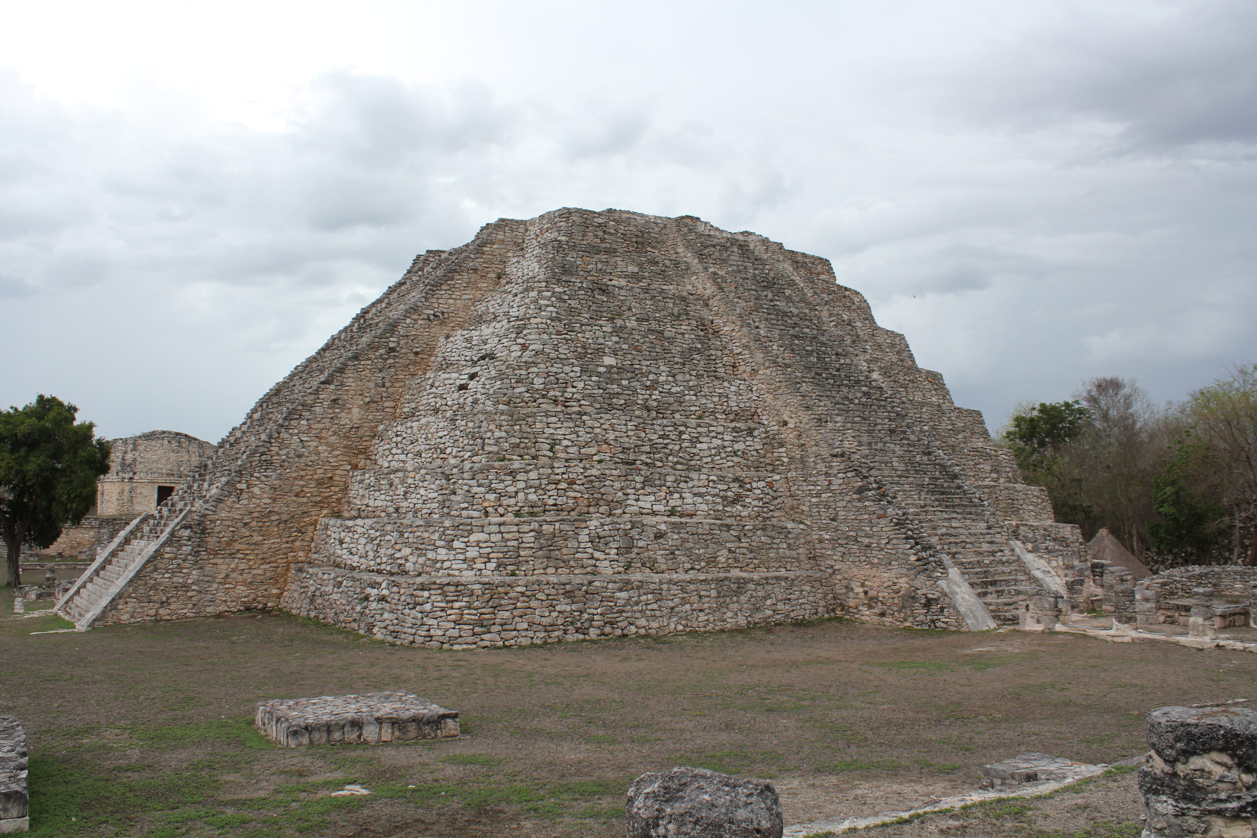
Mayapán (Máayapáan), often called the “Banner of the Maya,” was the last great capital of the northern Maya during the Late Postclassic era (ca. 1220–1440 CE). Within its defensive walls lie more than 4,000 documented structures packed into ~4 km²—temples, shrines, colonnaded halls, residences, and dozens of cenotes—offering a rare look at a densely urbanized Maya city. Its main pyramid (Temple of Kukulcán) and unusual round temples echo Chichén Itzá’s forms while showcasing Mayapán’s own late innovations.
Important status notice: The archaeological zone is closed to visitors until further notice due to an unresolved dispute between the federal heritage authority (INAH) and the local ejido of Telchaquillo, which has blocked access since 2023. If/when conditions change, we will update this guide; for now, plan alternatives.
History
Rise as a late Maya capital. After the decline of Chichén Itzá, Mayapán became the political and ritual center of Yucatán in the 13th–15th centuries, ruling through powerful lineages such as the Cocom and interacting with the Tutul Xiu—groups traditionally linked (with Uxmal and others) in the so-called League of Mayapán.
Urban scale and society. Inside its city wall, surveys record thousands of structures and population estimates of roughly 12,000–17,000 people at its height. Dense residential patio groups, small shrines, and many cenotes ring the ceremonial core, suggesting a vibrant, diverse urban life.
Civil strife and collapse. Ethnohistoric accounts describe factional conflict—especially between the Cocom and Xiu—and a mid-15th-century revolt that ended Mayapán’s hegemony. Recent research links this political violence to drought events that undermined stability, contributing to abandonment by the late 1400s.
Modern exploration. Professional work began in the 20th century (Carnegie Institution and later projects), with ongoing studies and conservation by Mexican and international teams.
Practical Information
- Status: Closed until further notice (entrance blocked by Telchaquillo ejido; no ticketing or services).
- Hours: Closed (previously 8:00–17:00).
- Entry Fee: N/A while closed.
- Best Time: N/A while closed (historically early morning for cooler temps).
- Facilities: None available during closure (previously parking, restrooms, signage).
Why it’s closed & who’s involved. Since 2023, the Telchaquillo ejido has maintained a blockade, seeking co-administration, control or sharing of guide/ticketing schemes, and compensation for decades of site use. Reports note an INAH proposal to expropriate ~14 hectares for compensation (rejected by the ejido), and continued demands for back payments and shared governance; as of October 2025, no final agreement has been announced publicly.
What is INAH? The Instituto Nacional de Antropología e Historia is Mexico’s federal agency charged with researching, conserving, and managing archaeological and historical heritage, with regional centers in every state (founded 1939). Think of it as the national steward of archaeological sites.
What is an ejido? In Mexico, an ejido is a legally recognized communal landholding created by agrarian reform; decisions are made by the ejido assembly of ejidatarios (rights-holding members). Ejidos control use and usufruct of their lands under the Ley Agraria. This local governance is central to the Mayapán dispute because site access crosses ejido land.
What to Expect
Current reality: Do not expect access to the ruins, parking area, or services; visitors are being turned away at the entrance due to the ongoing blockade. Respect closures and local authorities. When open (for context): The ceremonial core clusters around the Temple of Kukulcán (Q-162), flanked by three rare round temples associated with the wind aspect of Kukulcán/Quetzalcóatl; there is notably no ballcourt. The urban plan shows dense patio groups and more than 40 cenotes, with a walled oval enclosure punctuated by 12 gates and vaulted entrances.
Getting There
Location: Near the town of Telchaquillo, Tecoh Municipality, ~40 km SE of Mérida, off the Mérida–Chetumal highway (MEX-184). Travel is not recommended for the purpose of entry while the site remains closed.
Coordinates for reference (not for travel during closure): 20.62944, −89.46056.
What to Bring
- Alternate plans (see Nearby Attractions) in case the closure persists.
- Water, sun protection, and cash if traveling in the area; services are limited in rural zones.
- Respectful attitude toward local communities and authorities.
Tips & Safety
- Do not attempt to bypass any barricades or negotiate private entry; this risks legal trouble and community conflict.
- Follow official INAH/Yucatán Center channels for any reopening notice (Centro INAH Yucatán publishes status updates).
- Roads are rural; drive carefully, watch for livestock and speed bumps (topes).
- Heat and sun exposure are intense most of the year; plan accordingly if transiting the area.
Nearby Attractions
- Acanceh: Town pyramids and colonial church, ~25–30 km from Mérida.
- Haciendas & cenotes of Homún/Cuzamá: Popular swimming cenotes and rural day trips east of Mérida.
- Uxmal (if open): Major Puuc-style capital southwest of Mérida.
- Mérida Historic Center: Museums, markets, and weekly cultural events.
Mayapán Ruins: History, Layout & Closure
On This Page
Mayapán, last great Maya capital near Mérida, is closed due to an INAH–ejido dispute. Learn its deep history, city layout, and what the closure means for visitors.
Our Take
"Mayapán is the climbable alternative to Chichén—circular observatory, compact layout, and the thrill of summiting a K’uk’ulkan pyramid without the crowds."
What Makes This Special
Mayapán (Máayapáan), often called the “Banner of the Maya,” was the last great capital of the northern Maya during the Late Postclassic era (ca. 1220–1440 CE). Within its defensive walls lie more than 4,000 documented structures packed into ~4 km²—temples, shrines, colonnaded halls, residences, and dozens of cenotes—offering a rare look at a densely urbanized Maya city. Its main pyramid (Temple of Kukulcán) and unusual round temples echo Chichén Itzá’s forms while showcasing Mayapán’s own late innovations.
Important status notice: The archaeological zone is closed to visitors until further notice due to an unresolved dispute between the federal heritage authority (INAH) and the local ejido of Telchaquillo, which has blocked access since 2023. If/when conditions change, we will update this guide; for now, plan alternatives.
History
Rise as a late Maya capital. After the decline of Chichén Itzá, Mayapán became the political and ritual center of Yucatán in the 13th–15th centuries, ruling through powerful lineages such as the Cocom and interacting with the Tutul Xiu—groups traditionally linked (with Uxmal and others) in the so-called League of Mayapán.
Urban scale and society. Inside its city wall, surveys record thousands of structures and population estimates of roughly 12,000–17,000 people at its height. Dense residential patio groups, small shrines, and many cenotes ring the ceremonial core, suggesting a vibrant, diverse urban life.
Civil strife and collapse. Ethnohistoric accounts describe factional conflict—especially between the Cocom and Xiu—and a mid-15th-century revolt that ended Mayapán’s hegemony. Recent research links this political violence to drought events that undermined stability, contributing to abandonment by the late 1400s.
Modern exploration. Professional work began in the 20th century (Carnegie Institution and later projects), with ongoing studies and conservation by Mexican and international teams.
Practical Information
- Status: Closed until further notice (entrance blocked by Telchaquillo ejido; no ticketing or services).
- Hours: Closed (previously 8:00–17:00).
- Entry Fee: N/A while closed.
- Best Time: N/A while closed (historically early morning for cooler temps).
- Facilities: None available during closure (previously parking, restrooms, signage).
Why it’s closed & who’s involved. Since 2023, the Telchaquillo ejido has maintained a blockade, seeking co-administration, control or sharing of guide/ticketing schemes, and compensation for decades of site use. Reports note an INAH proposal to expropriate ~14 hectares for compensation (rejected by the ejido), and continued demands for back payments and shared governance; as of October 2025, no final agreement has been announced publicly.
What is INAH? The Instituto Nacional de Antropología e Historia is Mexico’s federal agency charged with researching, conserving, and managing archaeological and historical heritage, with regional centers in every state (founded 1939). Think of it as the national steward of archaeological sites.
What is an ejido? In Mexico, an ejido is a legally recognized communal landholding created by agrarian reform; decisions are made by the ejido assembly of ejidatarios (rights-holding members). Ejidos control use and usufruct of their lands under the Ley Agraria. This local governance is central to the Mayapán dispute because site access crosses ejido land.
What to Expect
Current reality: Do not expect access to the ruins, parking area, or services; visitors are being turned away at the entrance due to the ongoing blockade. Respect closures and local authorities. When open (for context): The ceremonial core clusters around the Temple of Kukulcán (Q-162), flanked by three rare round temples associated with the wind aspect of Kukulcán/Quetzalcóatl; there is notably no ballcourt. The urban plan shows dense patio groups and more than 40 cenotes, with a walled oval enclosure punctuated by 12 gates and vaulted entrances.
Getting There
Location: Near the town of Telchaquillo, Tecoh Municipality, ~40 km SE of Mérida, off the Mérida–Chetumal highway (MEX-184). Travel is not recommended for the purpose of entry while the site remains closed.
Coordinates for reference (not for travel during closure): 20.62944, −89.46056.
What to Bring
- Alternate plans (see Nearby Attractions) in case the closure persists.
- Water, sun protection, and cash if traveling in the area; services are limited in rural zones.
- Respectful attitude toward local communities and authorities.
Tips & Safety
- Do not attempt to bypass any barricades or negotiate private entry; this risks legal trouble and community conflict.
- Follow official INAH/Yucatán Center channels for any reopening notice (Centro INAH Yucatán publishes status updates).
- Roads are rural; drive carefully, watch for livestock and speed bumps (topes).
- Heat and sun exposure are intense most of the year; plan accordingly if transiting the area.
Nearby Attractions
- Acanceh: Town pyramids and colonial church, ~25–30 km from Mérida.
- Haciendas & cenotes of Homún/Cuzamá: Popular swimming cenotes and rural day trips east of Mérida.
- Uxmal (if open): Major Puuc-style capital southwest of Mérida.
- Mérida Historic Center: Museums, markets, and weekly cultural events.
Location
Plan Your Visit
Alternate plans, water, sun protection, cash
None available during closure; previously restrooms, signage, parking
Respect closures; monitor Centro INAH Yucatán for updates