Yaxuná (Yaxunah) Archaeological Site: Deep History & Its Chichén Itzá Connection
What Makes This Special
Yaxuná (often spelled Yaxunah) is a living Maya community wrapped around a quietly powerful archaeological zone just south of Chichén Itzá. It’s where deep-time history meets present-day culture: you can walk early ceremonial plazas and E-Group architecture, trace the line of a legendary sacbé (raised stone road) that once ran 100 km to Cobá, and then cool off at the community-run Cenote Lol-Há. Crucially, Yaxuná sat on the geopolitical fault line between Cobá and Chichén Itzá, and its ruins preserve physical evidence of that struggle.
Deep History in Brief
- Formative beginnings: Yaxuná’s core shows continuous occupation from the Middle/Late Formative through the Postclassic, with early E-Group complexes used for ritual, observation, and community gatherings.
- Classic rise & road-building: By the Late Classic (c. 600–800 CE), Cobá extended its influence westward and built the longest known Maya causeway—about 100 km—from Cobá to Yaxuná (Sacbé 1), cementing political and economic ties.
- Terminal Classic conflict: As Chichén Itzá’s power surged (c. 800–1000 CE), Yaxuná fortified itself with defensive walls. Archaeology points to an eventual Itzá conquest marked by ritual “termination” deposits—stonework sealed with offerings and human remains—especially around a council house (Popol Nah). The city never fully recovered.
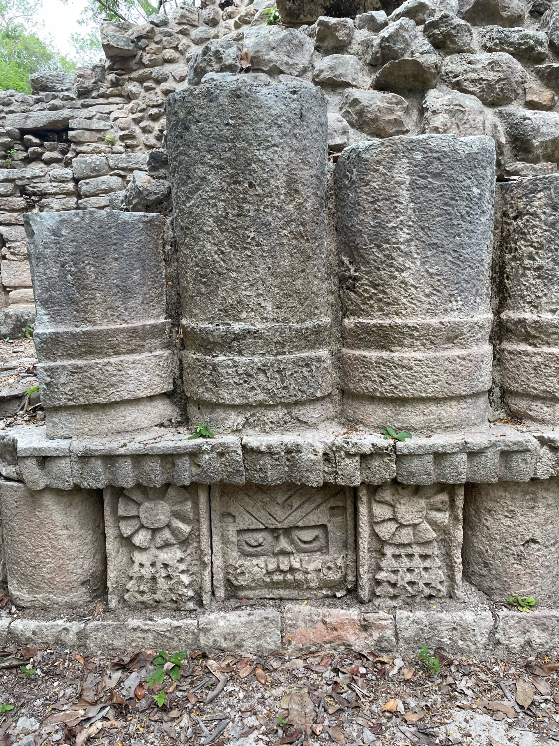
Today, much of Yaxuná remains lightly restored. That intimacy is the charm: quiet trails through milpa country, bird calls, and up-close looks at masonry, masks, and platforms without big-site crowds.
Yaxuná & Chichén Itzá: How They Connect
Geographically, Yaxuná lies roughly 20–25 km south of Chichén Itzá, making it an easy side trip from Pisté. Historically, Yaxuná was a contested node between the eastern superpower Cobá and the northern hegemon Chichén Itzá. Control of Yaxuná meant control of movement along the sacbé network, access to hinterlands, and influence over routes that stitched the peninsula together. Visiting both sites in one day lets you feel that story: the monumental theater of Chichén Itzá versus the quieter—but telling—defenses and ritualized endings at Yaxuná.
Practical Information
- Hours (ruins): Informal daylight access via community trails (no formal INAH ticket booth on site; respect closures/signage).
- Entry Fee (ruins): Often free or by donation via the community parador or guided visit. Cenote Lol-Há: ~$100 MXN; typically open 9:00 AM–5:00 PM.
- Recommended Visit Length: 1.5–3 hours (add 45–60 min if swimming at the cenote).
- Difficulty: Easy–moderate (flat terrain; some uneven stones and low steps).
- Facilities: Community parador and Cenote Lol-Há (parking, basic restrooms). Minimal signage at the ruins.
- Payments: Bring cash (small bills) for cenote and community tours.
- Phone (community/tour inquiries): +52 985 114 0808 (Yucatán tourism listing).
- Accessibility: Not wheelchair accessible; expect dirt tracks and rubble-core platforms.
- Best Time: Early morning or late afternoon for softer light and cooler temps.
What to Expect
- E-Group & early plazas: Low platforms and alignments tied to early ceremonial practice.
- North Acropolis & civic spaces: Long platforms with pyramidal mounds and room blocks in various states of conservation.
- Defensive works & “termination” contexts: Traces of city walls and sealed deposits from the conflict with Chichén Itzá.
- Sacbé heritage: Walk segments aligned with the famed Cobá–Yaxuná road (interpretive traces vary).
- Community vibe: Quiet paths, milpa fields, birds, and a welcoming pueblo—pair ruins with a refreshing cenote swim.
Getting There
Location: About 20–25 km south of Chichén Itzá (Pisté). From Pisté, take Calle 22 south ~22 km to Yaxuná; the archaeological zone sits near the village. Driving from Mérida or Valladolid is straightforward via Hwy 180 then the local spur.
- From Pisté/Chichén Itzá: Follow Calle 22 south ~22 km; look for village/ruins turnoffs.
- From Mérida (2–2.5 hrs): Hwy 180 east toward Pisté → south on Calle 22.
- Without a car: Colectivos run to Pisté; from there, hire a taxi to Yaxuná and arrange round-trip/wait time. Community tours can sometimes assist with transport—ask at the parador.
What to Bring
- Water (at least 1–1.5 L per person)
- Sun protection (hat, sunglasses, mineral sunscreen)
- Closed-toe shoes with grip (uneven stones)
- Light long sleeves/pants (sun & insects)
- Cash in small bills for cenote/tours
- Offline map/notes (signal can be patchy)
Tips & Safety
- Respect community spaces: Ask before flying drones; follow local guidance on where to walk.
- Pair thoughtfully: Do Chichén Itzá at opening, then Yaxuná + Cenote Lol-Há for a restorative, crowd-free afternoon.
- Footing: Watch loose stones/rubble; avoid climbing fragile mounds.
- Hydration & shade: Limited vendors; bring water and take breaks.
Nearby & Pairings
- Chichén Itzá (UNESCO): 20–25 km north; world-class monuments and museums.
- Cenote Lol-Há (Yaxuná): Community-run, usually open 9–5; lifejackets for rent; mellow vibe.
- Pisté: Services, ATMs, eateries; gateway to Chichén.
- Valladolid: Charming colonial hub ~40–50 min east with cenotes and dining.
FAQs
- Is there an official ticket booth? No—access is community-managed; consider a guided visit via the parador. The cenote charges a small fee.
- How long do I need? 1.5–3 hours including the cenote; archaeology buffs can linger longer.
- Why is Yaxuná important? It anchors the west end of the 100 km Cobá causeway and preserves rare evidence of Terminal Classic conflict with Chichén Itzá.
Yaxuná (Yaxunah) Archaeological Site: Deep History & Its Chichén Itzá Connection
On This Page
A quiet, living-community site just south of Chichén Itzá: early E-Group plazas, the far end of Cobá’s 100-km sacbé, and vivid traces of the Itzá conquest—finished with a swim at Cenote Lol-Há.
Our Take
"Yaxuná is the connective tissue between kingdoms—climb the pyramids, walk the sacbé toward Cobá in your mind, and swim the community cenote to cool off afterward."
What Makes This Special
Yaxuná (often spelled Yaxunah) is a living Maya community wrapped around a quietly powerful archaeological zone just south of Chichén Itzá. It’s where deep-time history meets present-day culture: you can walk early ceremonial plazas and E-Group architecture, trace the line of a legendary sacbé (raised stone road) that once ran 100 km to Cobá, and then cool off at the community-run Cenote Lol-Há. Crucially, Yaxuná sat on the geopolitical fault line between Cobá and Chichén Itzá, and its ruins preserve physical evidence of that struggle.
Deep History in Brief
- Formative beginnings: Yaxuná’s core shows continuous occupation from the Middle/Late Formative through the Postclassic, with early E-Group complexes used for ritual, observation, and community gatherings.
- Classic rise & road-building: By the Late Classic (c. 600–800 CE), Cobá extended its influence westward and built the longest known Maya causeway—about 100 km—from Cobá to Yaxuná (Sacbé 1), cementing political and economic ties.
- Terminal Classic conflict: As Chichén Itzá’s power surged (c. 800–1000 CE), Yaxuná fortified itself with defensive walls. Archaeology points to an eventual Itzá conquest marked by ritual “termination” deposits—stonework sealed with offerings and human remains—especially around a council house (Popol Nah). The city never fully recovered.
Today, much of Yaxuná remains lightly restored. That intimacy is the charm: quiet trails through milpa country, bird calls, and up-close looks at masonry, masks, and platforms without big-site crowds.
Yaxuná & Chichén Itzá: How They Connect
Geographically, Yaxuná lies roughly 20–25 km south of Chichén Itzá, making it an easy side trip from Pisté. Historically, Yaxuná was a contested node between the eastern superpower Cobá and the northern hegemon Chichén Itzá. Control of Yaxuná meant control of movement along the sacbé network, access to hinterlands, and influence over routes that stitched the peninsula together. Visiting both sites in one day lets you feel that story: the monumental theater of Chichén Itzá versus the quieter—but telling—defenses and ritualized endings at Yaxuná.
Practical Information
- Hours (ruins): Informal daylight access via community trails (no formal INAH ticket booth on site; respect closures/signage).
- Entry Fee (ruins): Often free or by donation via the community parador or guided visit. Cenote Lol-Há: ~$100 MXN; typically open 9:00 AM–5:00 PM.
- Recommended Visit Length: 1.5–3 hours (add 45–60 min if swimming at the cenote).
- Difficulty: Easy–moderate (flat terrain; some uneven stones and low steps).
- Facilities: Community parador and Cenote Lol-Há (parking, basic restrooms). Minimal signage at the ruins.
- Payments: Bring cash (small bills) for cenote and community tours.
- Phone (community/tour inquiries): +52 985 114 0808 (Yucatán tourism listing).
- Accessibility: Not wheelchair accessible; expect dirt tracks and rubble-core platforms.
- Best Time: Early morning or late afternoon for softer light and cooler temps.
What to Expect
- E-Group & early plazas: Low platforms and alignments tied to early ceremonial practice.
- North Acropolis & civic spaces: Long platforms with pyramidal mounds and room blocks in various states of conservation.
- Defensive works & “termination” contexts: Traces of city walls and sealed deposits from the conflict with Chichén Itzá.
- Sacbé heritage: Walk segments aligned with the famed Cobá–Yaxuná road (interpretive traces vary).
- Community vibe: Quiet paths, milpa fields, birds, and a welcoming pueblo—pair ruins with a refreshing cenote swim.
Getting There
Location: About 20–25 km south of Chichén Itzá (Pisté). From Pisté, take Calle 22 south ~22 km to Yaxuná; the archaeological zone sits near the village. Driving from Mérida or Valladolid is straightforward via Hwy 180 then the local spur.
- From Pisté/Chichén Itzá: Follow Calle 22 south ~22 km; look for village/ruins turnoffs.
- From Mérida (2–2.5 hrs): Hwy 180 east toward Pisté → south on Calle 22.
- Without a car: Colectivos run to Pisté; from there, hire a taxi to Yaxuná and arrange round-trip/wait time. Community tours can sometimes assist with transport—ask at the parador.
What to Bring
- Water (at least 1–1.5 L per person)
- Sun protection (hat, sunglasses, mineral sunscreen)
- Closed-toe shoes with grip (uneven stones)
- Light long sleeves/pants (sun & insects)
- Cash in small bills for cenote/tours
- Offline map/notes (signal can be patchy)
Tips & Safety
- Respect community spaces: Ask before flying drones; follow local guidance on where to walk.
- Pair thoughtfully: Do Chichén Itzá at opening, then Yaxuná + Cenote Lol-Há for a restorative, crowd-free afternoon.
- Footing: Watch loose stones/rubble; avoid climbing fragile mounds.
- Hydration & shade: Limited vendors; bring water and take breaks.
Nearby & Pairings
- Chichén Itzá (UNESCO): 20–25 km north; world-class monuments and museums.
- Cenote Lol-Há (Yaxuná): Community-run, usually open 9–5; lifejackets for rent; mellow vibe.
- Pisté: Services, ATMs, eateries; gateway to Chichén.
- Valladolid: Charming colonial hub ~40–50 min east with cenotes and dining.
FAQs
- Is there an official ticket booth? No—access is community-managed; consider a guided visit via the parador. The cenote charges a small fee.
- How long do I need? 1.5–3 hours including the cenote; archaeology buffs can linger longer.
- Why is Yaxuná important? It anchors the west end of the 100 km Cobá causeway and preserves rare evidence of Terminal Classic conflict with Chichén Itzá.
Location
Plan Your Visit
Water, hat, sunscreen, insect repellent (wet season), sturdy shoes, cash (small bills)
Community parador; Cenote Lol-Há with basic restrooms and lifejackets; minimal signage at ruins
Hire a community guide; combine with Cenote Lol-Há; arrange taxi round-trip from Pisté if without a car